The Ministry of Health and Wellness wishes to remind the public of the areas of interest for the quarantined communities in St. Mary.
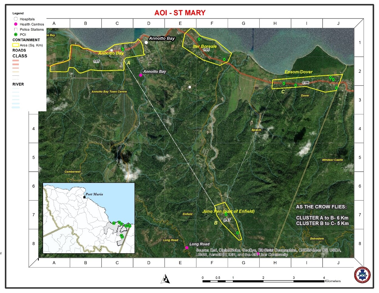
ANNOTTO BAY QUARANTINE AREA (PART OF ANNOTTO BAY)
The area of interest spans 1.81 Sq. Km and is bounded by an 8 km perimetre.
EAST
The boundary will run from its start point at the intersection of Gibraltar Heights Road and the North Coast Highway and head in a northerly direction to the coastline.
NORTH
It will run in a westerly direction along the coastline for approximately 1.86 km, then along the North Coast Highway for approximately 1.65 km to its junction with a minor road.
WEST
The boundary will continue in a southerly direction along the minor road for approximately 0.18 km to its junction with another minor road at the south-west corner of the Gray’s Inn Sports Complex.
SOUTH
The boundary will then run in a generally easterly direction along the southern boundary of the Gray’s Inn Sports Complex and the Gray’s Inn Great House following the minor road for 2.59 km to its junction at Fort George Road, thereafter following an imaginary line which will run to the north of the Ross Drive community, ending along the Gibraltar Heights Road. The boundary will then follow Gibraltar Heights Road in a northerly direction to the start point.
ITER BOREALE QUARANTINE AREA
The area of interest spans 1.1 Sq. Km and is bounded by a 4.31 km perimetre.
EAST
The boundary will run from its start point along the Enfield Main Road at its junction with a minor road approximately 150m south of the North Coast Highway, in a northerly direction towards the coast for a distance of 0.53 km.
NORTH
It will then run in a westerly direction along the coast for 1.64 km.
WEST
The boundary will then continue in a south-westerly direction for a distance of approximately Two Hundred and Thirty (230m) to a point south of the North Coast Highway.
SOUTH
The boundary will then run in an easterly direction along the southern outskirts of the community to the start point along the Enfield Main Road.
JUNO PEN (PART OF ENFIELD)
The area of interest spans 0.47 Sq. km and is bounded by a 2.24 km perimetre.
EAST
The boundary will run from a point along the Enfield Main Road 0.23 km north of the Juno Pen Bridge, east for Forty Meters (40m), then in a northwesterly direction for a distance 1.33 km.
NORTH
It will then run in a westerly direction for approximately 0.37 km across the Enfield Main Road to an open lot west of the said road.
WEST
The boundary will then continue in a southeasterly direction for a distance of approximately 1.42 km to a point west of the starting point.
SOUTH
The boundary will then continue in an easterly direction to the start point at the Enfield Main Road.
EPSOM/DOVER QUARANTINE AREA
The area of interest spans 0.83 Sq. Km and is bounded by a 5.34 km perimetre.
EAST
The boundary will run from its start point where the Dover to Portland Main Road intersects with the Parish Boundary, in a northerly direction along the Parish Boundary, for a distance of
0.23 km.
NORTH
It will then run in a westerly direction for approximately 2.29 km to the
north-western boundary of a property north of the Dover to Portland Main Road.
WEST
The boundary will then continue in a southerly direction across the Dover to Portland Main Road for a distance of approximately 0.34 km.
SOUTH
The boundary will then continue along an imaginary line along the southern outskirts of the community to the dry gully south of the start point, and then in a northerly direction to the start point.